Mears Peak
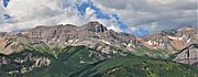
Mountain in Colorado, United StatesMears Peak is a 13,496-foot-elevation (4,114-meter) mountain summit located on the common boundary of Ouray County with San Miguel County, in Colorado, United States. It is situated six miles northwest of the community of Telluride, in the Mount Sneffels Wilderness, on land managed by Uncompahgre National Forest. It is part of the Sneffels Range which is a subset of the San Juan Mountains, which in turn is part of the Rocky Mountains. Mears Peak is situated west of the Continental Divide, and 3.8 miles west of Mount Sneffels. Topographic relief is significant as the south aspect rises 4,900 feet above the San Miguel River in approximately 5.5 miles.
Read article


Top Questions
AI generatedMore questions
Nearby Places

Mount Sneffels Wilderness
U.S. Wilderness Area in southwest Colorado managed by the Uncompahgre National Forest
Mount Sneffels
Mountain in Colorado, United States

Sneffels Range
Mountain range in Colorado, United States
Dallas Peak
Mountain in Colorado, United States

Gilpin Peak
Mountain in Colorado, United States

Hayden Peak (San Miguel County, Colorado)
Mountain in the state of Colorado

Mount Emma
Mountain in Colorado, United States

North Pole Peak
Mountain in Colorado, United States